le Rove du 24 10 22

tessonnierg
User
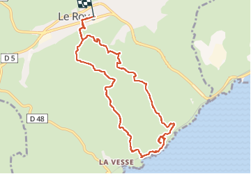

Length
11 km

Max alt
203 m

Uphill gradient
344 m
Km-Effort
15.6 km

Min alt
25 m

Downhill gradient
344 m
Boucle
Yes
Creation date :
2022-10-24 08:39:38.785
Updated on :
2022-10-24 13:49:16.561
4h36
Difficulty : Difficult

FREE GPS app for hiking
 SityTrail
IGN / Geographical institutes
SityTrail Plus
The world is yours!
About
Trail Walking of 11 km to be discovered at Provence-Alpes-Côte d'Azur, Bouches-du-Rhône, Le Rove. This trail is proposed by tessonnierg.
Description
a effacer
Positioning
Country:
France
Region :
Provence-Alpes-Côte d'Azur
Department/Province :
Bouches-du-Rhône
Municipality :
Le Rove
Location:
Unknown
Start:(Dec)
Start:(UTM)
682619 ; 4804259 (31T) N.
Comments